Kane Creek “Preservation” and Development
Where old cottonwoods once majestically stood, machines make way for a luxury development outside of Moab, Utah
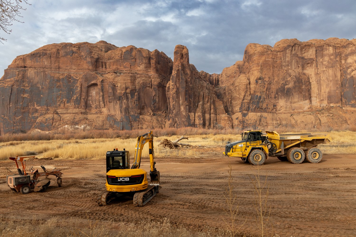
When you leave the town of Moab, Utah, and drive along the Colorado River to the West, you soon pass through what is known as “The Portal”, entering into a uniquely beautiful canyon corridor with sublime views and natural wonders. Outdoor recreators of all kinds come here to escape to a place of peace. Now, work on a luxury development situated on the floodplain there has drastically changed the landscape and habitat, though just in the early stages. One of the first things they did was to remove many of the old cottonwood trees, and since then they’ve mostly just been stripping land from one place and filling in the floodplain.

In a county commision meeting in January, community members spoke out against the development. One comment that stuck out to me comes from Jason Ramsfeld, who has lived in Moab for 20 years: “Development is normal in and around a gateway community…but the difference is that things change, things change when you go around the corner and things change when you go through the portal, and to me, that is a national park quality area. That’s the difference. And I was just up there yesterday recreating, and I just started thinking about all the areas up there that are national park quality areas, Moab Rim, Moonflower Canyon, Pritchett Canyon, Tombstone, Amasa Back, Jackson Trail, and the list goes on…we’re all going to be affected, by the noise, the pollution, the emissions, you name it, and this type of development does not belong in a national park quality area like Kane Springs area and the Colorado River.”
Below, gravel that was stripped from nearby land is being used to fill in the floodplain to prepare for construction.

The main purpose of this page is to help visualize the negative impacts that this development has and will continue to have in our lifetimes and future generations if it is not stopped. It’s easy to see why many laugh at the developers’ name, ‘Kane Creek “Preservation” and Development’, and why we always use quotes around “Preservation” in it. For the images below, drag the slider to compare before and after. I appreciate the photographers who have given permission to use their images here. Credits are in the captions above each comparison. While some of the images are original photos taken before work began, or more recently to show what it’s looking like, others have been edited and utilize AI to try and imagine what development in the area could look like in the future. In those cases, it should not be viewed as what it will look like, but rather a representation to give an idea why the project appears to be all about destruction, greed, and money - not preservation. Note that on some devices there may be some odd spacing issues, so to ensure you see them all, be sure to keep scrolling until you reach the bottom.
Below, compare an older photo of the land to a more current one since development has begun.
Image Credits: Before - Eric Odenthal, After - Kane Creek Development Watch
Below, compare aerial imagery from Google Earth from before development, to May 2024, after the Cottonwoods were cut down and the floodplain was being filled in.
Below, an older photo of some of the cottonwoods on the land, compared to what it’s looking like after the trees were removed to make way for the development.
After - AI modification to show what it looks like after tree removal.
Below, compare a fairly recent photo of the land taken from across the river, to an AI modification showing how development could affect the landscape.
Image Credits: Before - Zach Cooley, After - AI modification
Below, compare an aerial view of the river corridor from before work began, to an AI modified images showing homes where the development is occuring.
Image Credits: Before - Miso Tunks, After - AI modification
Below, compare a before image (though the land had already been changed by the development), to an AI modification showing homes where the development is occurring.
Image Credits: Before - Zach Cooley, After - AI modification
The reasons that so many people in the Moab community are against this project are many, and while I could write plenty about those, I wanted to focus on the visuals here. If you are interested in learning more, I encourage you to visit the Kane Creek Development Watch website, as they provide a wealth of information. Also, regardless of where you live, you can also sign their petition to demonstrate opposition to the project, or donate to help with legal battles as they fight to safeguard the area from the development.
I would like to update this page as I take additional photos, and if anybody would like to contribute others, please contact me. Especially helpful would be good overview photos of the land from before development began, as well as any newer photos showing the destruction of the land.